Showing posts with label drought. Show all posts

Monday, July 9, 2007

Community Gardens

Community gardens and City Farms are not just about changing climate back. They are about adapting to changing climate in such a way that could be exemplary even after climate consolidated. http://www.placemark.com.au/community-gardens.html
Why you ask? Because the loss of agricultural land is already a reality as well as genetically tempered produce that is out of public control (in part because companies make the the production "blue-print" commercially confidential.)

Add to it that we may start assigning increasing amount of land to growing crops for burning it as fuel just to get from A to B (that is for bio-ethanol or bio-fuel.) That takes them out of the zero sum game, that is the amount of land available globally for agricultural produce. As a result, the intensity with which the public will require clean and controlled production of food produce (and possible hobby plants and cut flowers that are not toxic or contaminated) may in turn increase dramatically - no matter what.

The extending drought and the shortage of irrigation water bringing these gardens to life and making them ever more popular. My hunch is that as they will grow in size they will inevitably specialize. But until then I would like to see them managed for growth or just simply better managed in the face of inherent conflicts of interest implicit in running many of them.

Related links and posts:
Serious problems inside community gardens: http://forums.gardenweb.com/forums/../msg0314133824873.html?15
Over-consumed land and other resources:
changeclimateback.blogspot.com/../problem-with-overconsumption.html

Thursday, April 26, 2007

Global Climate Engine 3D Animated


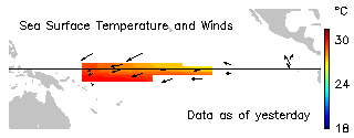
This is where the cookie crumbles. The Pacific near surface water body temperature is the Number One Global Climate Engine. This where El-Nino and La-Nina form - the climate events of planetary length and reach. They can last up to 3-5 years bringing drought or rain to areas across the Globe respectively.

Pictured is our best hope for a La-Nina - again - in nearly 60 months - that is 5 years. The cool blue shows colder surface temperature where it should be - in the Eastern Equatorial Pacific region. But previous patterns show that it needs to "bite in" for more than the half the with of the Pacific Ocean for a La-Nina to successfully stabilise.

If you switch animation to slow, you'll see that such conditions where formed a few times, none of them bringing a real La-Nina yet. Now is the chance.

Saturday, April 21, 2007

La Nina may bring RAIN and break the drought

The satellite image was computed from a multiple of buoy data (Feb. 28, 2007)

I have been following this for a few weeks now. We all know that El Nino is officially over. It is common wisdom, that La Nina (the opposite of El Nino) tends to form on the tail of its brother waning away. And now it appears that oceanic surface tempereature drop in the Equatorial Pacific (a main pattern of La Nina formation) is spreading or at least has been stabilising over the past weeks or so.
A recent update was computed (Apr. 20, 2007)
Here you can follow current data all the time.
http://www.pmel.noaa.gov/tao/

If the trend continues, welcome rain may arrive at North-Eastern Australia.
It is too early to tell though the signs are welcoming.

At the very least I am going to clean the old gutter below the eucalipt tree that I've been putting off for some time now. So when the rain comes the pipes won't be blocked. Even if it is unlikely that Victoria will receive a lot of it. But who knows, with Gods help we just might.

You folks out there don't know what RAIN will mean in Australia. We currently have the dire prospect officially announced by the PM, that the food bowl of our country (The Murray-Darling river and catchment area) will be stopped in about 5-6 weeks if welcome rain does not arrive.

So severe is the drought at the moment. Let's not contemplate what that might mean in terms of inflation and rates. Let's welcome the rain with all our heart. Let's hope that La Nina will be mighty gracious.

NOAA News Online (Story 2805)

Saturday, February 17, 2007

The Gulf slowing, but Why? And Why bother...

A crucial and far-reaching feedback in global warming and subsequent climate change is the slowing down of the Atlantic thermohaline circulation colloquially known as the Gulf stream.

If the Gulf current weakens further...

When it happened before ( and it happened - according to native Americans memories) the midland drought on the American continent lasted 40 continous and relentless years. Currently we could be in about the third...

Kuro-siwa and Gulf

The two most important oceanic streams known are the Kuro-siwa in the Pacific and the Gulf Current in the North Atlantic. Both already weakened and continue to weaken. The first is getting diluted by ice melting in the Antarctic and the second - by the ice melting in the Polar Ice cap and the Greenland ice sheet.

Out of the two the Gulf may be at larger risk. In the picture below you can see streams along the coast lines. The blue and green streams are deep ocean currents carrying heavy and more salty cold water. The orange and red ones are the warm surface currents. Between the two are yellow streams.


There are many things that effect circulation, but here we'll concentrate on two. One is the heavy salt that makes cold water sink so it can remain cold while it journeys back to the Mexican Gulf. The second is the many multitudes of smaller streams around the Greenland plain that constitute mostly the cold back-flow. If there is no back flow - there is no current.

Warm surface water carries warm air above. That constant supply of warm air is responsible for the relatively mild climate of Northern Europe. The sun doesn't heat this area sufficiently, so without the Gulf circulating there would be no warm air here. The Gulf is the guardian angel of moderate climate in this region.

Imagine it slowing and slowing to the point where just the jagged edges of Greenland alone would pose a significant barrier to that flow. The South Pacific section of the Kuro-siwa is much less hampered by such impediments. That is quite a reason why the Gulf may be at a larger risk.


Now let's take a look at just how deep those cold currents are.


Very deep. This is a section across the Atlantic. To the left is the East coast with Florida, no mistake there. To the right are the Skandinavian peninsula, the UK, Spain and Africa. At the top is Greenland.

Beginning to have an idea of how the Gulf works? Great. Now take a closer look at where the sinking of cold water takes place? These points are called the Atlantic overturning points. The significant portion (the left part) of the Gulf sinks just off the coast at West Greenland. And what makes it possible? Salty water that is heavier than freshwater.

That is the same area where very significant build-up of fresh water reserves has been detected. Source? Melting Greenland freshwater ice sheets - there could be other reasons, but this is most compelling to consider. Important back-flowing section (the sinking part) of the Gulf is being bombarded by freshwater bombs breaking up the sinking stream into yet smaller streams. Coincidentally, the Gulf has been weakened. It has already slowed down about 30%.

This means that more and more of its activity is in the inner circle that just circulates warm water and air between the East Coast and Africa. Here, coastal surface water now often reaches an unbelievable 35 degrees centigrade. And when it does, it serves a perfect brewing ground for large and fast tornadoes.