La Nina may bring RAIN and break the drought
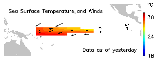
 The satellite image was computed from a multiple of buoy data (Feb. 28, 2007)
I have been following this for a few weeks now. We all know that El Nino is officially over. It is common wisdom, that La Nina (the opposite of El Nino) tends to form on the tail of its brother waning away. And now it appears that oceanic surface tempereature drop in the Equatorial Pacific (a main pattern of La Nina formation) is spreading or at least has been stabilising over the past weeks or so.
A recent update was computed (Apr. 20, 2007)
Here you can follow current data all the time.
http://www.pmel.noaa.gov/tao/
If the trend continues, welcome rain may arrive at North-Eastern Australia.Here you can follow current data all the time.
http://www.pmel.noaa.gov/tao/
It is too early to tell though the signs are welcoming.
At the very least I am going to clean the old gutter below the eucalipt tree that I've been putting off for some time now. So when the rain comes the pipes won't be blocked. Even if it is unlikely that Victoria will receive a lot of it. But who knows, with Gods help we just might.
You folks out there don't know what RAIN will mean in Australia. We currently have the dire prospect officially announced by the PM, that the food bowl of our country (The Murray-Darling river and catchment area) will be stopped in about 5-6 weeks if welcome rain does not arrive.
So severe is the drought at the moment. Let's not contemplate what that might mean in terms of inflation and rates. Let's welcome the rain with all our heart. Let's hope that La Nina will be mighty gracious.
NOAA News Online (Story 2805)


No comments:
Post a Comment